The Canyon was later dammed, forming Blue Ridge Reservoir, which serves as a water source for the mines in Globe. Ironically, exploitation of mineral deposits in places like Globe and Jerome were one of the major reasons that the Apache were being forced onto reservations and off their traditional hunting, farming, and raiding lands in the 1870's and 1880's.
In the last century this area has been grazed, logged, and natural fires have been suppressed, resulting in a denser forest of smaller trees instead of the open, park like pine forest that covered most of the area in the 1880's. In spite of this many of the rugged canyons in the area are in fairly pristine condition, and still have most of their original flora and fauna.
The pictures below are from the area where the battle occurred, and illustrate the traces of the battle still remaining, and the natural beauty that persists in the area to this day. (click for full sized versions)
The front side of the monument.
The back side of the monument, listing the troopers and Apache scouts present.
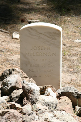
The only grave at the battlefield is Pvt. Joseph McLernon's. The Apaches who died in the battle were not buried, and were left where they fell. There is no record of what happened to the Scout who was killed.
The lower end of the ridge where the Apaches made their stand now lies under the waters of Blue Ridge Reservoir, which is often this green color due to algal blooms.
The view across the side canyon. The initial army positions were here, and the Apache group was on the ridge that is now barely visible through the trees.
A small bird bolted from under the rock just under this fence as I approached.
The nest, eggs, and first hatchling are hidden underneath.
Crackerbox canyon, about a mile southwest of the battlefield is named because of the empty hardtack boxes the army left here when they camped after the battle.
A cow elk or wapiti grazing on the lush growth of the creek bottom.
At least one bear has been foraging on the early growth as well.
A dead pine and a red-tailed hawk are the only sentinels now.
The bears may soon have wild strawberries to eat.
The view across the side canyon. The initial army positions were here, and the Apache group was on the ridge that is now barely visible through the trees.
This columbine, Aquilegia desertorum grows in the limestone crevices and ledges of the area
The nest, eggs, and first hatchling are hidden underneath.
Crackerbox canyon, about a mile southwest of the battlefield is named because of the empty hardtack boxes the army left here when they camped after the battle.
A cow elk or wapiti grazing on the lush growth of the creek bottom.
At least one bear has been foraging on the early growth as well.
A dead pine and a red-tailed hawk are the only sentinels now.
The bears may soon have wild strawberries to eat.


Hi, your article is incorrect about the water from Blue Ridge Reservoir. It flows into the East Verde River then into a Verde River reservoir north of Phoenix. This is no where close to Globe.
ReplyDeleteSee: www.paysonroundup.com/news/2012/may/04/blue-ridge-water-gushes-east-verde/
Yes, the water is pumped over the Mogollon rim to the south (it would naturally flow north into the Little Colorado). Technically that water does not go all the way to Globe, but the reason it is pumped into the Verde system is to replace water taken out farther downstream for the mines in Globe.I did simplify the situation greatly, but Blue Ridge Reservoir is indeed related to the mines in Globe, despite the distance. The history of water rights and use in AZ is convoluted and complex, and really beyond the scope of this Blog.
ReplyDeleteHere are more details (The reservior was built by Phelps Dodge in 1965)
ReplyDeletehttp://www.srpnet.com/water/dams/cragin.aspx
Thanks for the photos. I am taking some historical words from a participant in the Battle Of Big Dry Wash. These words caught my attention because they are quite curious. Maybe you can visit this place again some time and investigate.
ReplyDelete"Our (cavalry) column finally found a place where we could climb down the precipitous side of the chasm and had gained the beautiful stream that flows at the bottom (Of Big Dry Wash) when someone exclaimed and pointed up - every star was plainly visible in the sky at three-thirty in the afternoon."
Something to think about.
Pete, California
Hey Pete, I have read those comments before as well, and I think they are a little exaggerated. The side canyon the battle was fought across is not that precipitous, easy to walk down into it and out again in several places. the last 200 yards or so is quite steep where it joins the canyon of East Clear Creek. That canyon is partly filled with water now, but I have been into it in many places, and while there are some cliffs and dangerously steep places, there are a lot of places to get in and out as well. I think Phil Plait debunked the idea that you can ever find a deep enough hole to see stars during the middle of the day, although it was a common claim in the 19th century, and still pops up occasionally. If you can get hold of a copy, Al Seiber, Chief of Scouts by Dan Thrapp has the best account of the battle I have read.
ReplyDelete